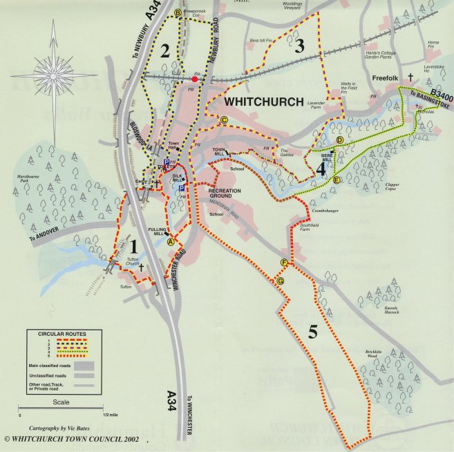
 There
are 5 walks for which there are detailed routes available.
There
are 5 walks for which there are detailed routes available.
The map to the left shows them. A fold out brochure for you to carry with you is available as an Adobe Acrobat download and the route descriptions are below.
You can start from the Silk Mill Car Park or Bell Street car park which is well signed from the Town centre.
![]() Walk 1
Walk 1
Tufton, River Test, Millennium Meadow
2� miles - approx 2 hr walk or short circular walk - approx � hr.
Directions
From Bell Street car park, go past the Public Toilets and turn right along footpath to Fairclose, then turn left to Church Street. Turn right along Church Street and continue on towards the Church.
From the Silk Mill, turn left into Winchester Street to the Square, keep left into Church Street but cross to the other side where there is a continuous footpath.
On your left is 'The Lawn' home of the late Lord Denning, former Master of the Rolls. Opposite All Hallows Church turn left alongside the garden wall of 'The Lawn' and continue down to the riverside, then right along the riverbank footpath towards the Fulling Mill. Pause to take a look back at the church, the Old Rectory and the Tythe Barns. Cross the footbridge to the Fulling Mill and dogleg across the road (The Weir) to the left and continue along narrow footpath, over a stile, and over the small footbridge to the meadows and a decorative bench (point A).
(Shortcut - Turn left alongside the fence here, across the meadows towards the Millennium Gate, through the gate and left along Winchester Road into Whitchurch town centre and the car parks.)
Continue straight across the meadow to Winchester Road, through the kissing gate and turn right along the road towards 'Ivy Cottage'. About 50m past 'Ivy Cottage' cross the stile on the right and continue diagonally across the meadow to the opposite left-hand comer, and through the metal gate to the road. Turn right under the A34 by-pass and immediately right again over a stile and along the footpath beside the bypass towards Tufton. Note Tufton Manor House on your left.
Follow the fence on your left around the field, over the stile at the end, and continue left through the Manor Farm complex, with its listed barns, towards the churchyard. Turn right at the telephone box (a proper red one!) and continue along the road past the Church of St. Mary - well worth a visit - and more barns to the river. Turn left along the road past Manor Farm house and Riverside Cottages to a metal gate across the road. Cross the stile to the right and continue over the footbridge across the river and over another stile. Turn left under the disused Great Western Railway arch and then turn right over two stiles and a small wooden footbridge. Carry on along the path at the base at the railway embankment and over another stile into the meadow. Listen and watch for Buzzards over Hurstbourne Park ahead of you. Cross the meadow diagonally to the left (follow posts) and cross the drain to a wooden gate and stile. Continue over the stile and keep to the left-hand hedge to the track uphill to the B3400 road. Take care in crossing the road here, up the steep bank on the opposite side from the track where you will find an iron bench at the top. Continue along the bank-top path, past the park gates, and under the A34 bypass. Follow the road back under the disused railway bridge and past the church into Church Street once more and turn left through xxx for Bell Street car park or continue on to the town centre and turn right into Winchester Street for the Silk Milk.
![]() Walk 2
Walk 2
Railway and Bridleway Walk
3� miles - approx 1� hrs.
Directions
From Bell Street car park go past the Public Toilets and turn right along footpath to Fairclose.
Continue up the path at the head of Fairclose behind the house to your left, which goes past Fairclose Terrace and the old Junior School (1845) to Wells Lane. Turn left along to All Hallows Church at the end of Wells Lane then turn right under the disused railway arch, and right again through a gate to the footpath on the left of the driveway beside the cemetery. At the top of the cemetery follow the driveway to the left of the house and through a metal gate into the field. Continue across field through an open gateway, then diagonally right across next field and over the stile next to the subway under the old Great Western Railway. Turn left along the path and through the kissing gate at the end (a tight squeeze!). Cross the field diagonally to the left to a stile, cross the stile and turn right through a metal gate to the road (Bloswood Lane). Cross the road to Bloswood Drive and follow the Bridleway sign to the end of the Drive, past the new housing development to the left, and along the track towards the allotments. At the entrance to the allotments turn left up narrow footpath, through opening in chain-link fence, and across field diagonally to the left towards the paired power supply poles on the skyline. Continue through the open gateway and across the footbridge over the main London to Exeter railway, the London & South West Railway which opened in 1854. Go through the metal gate then along the left-hand perimeter of the field adjacent the A34 as far as the footbridge, over it to Down Farm. Turn right along the track across the field to the gate, visible in the opposite hedge (point B).
(Shortcut - Continue across bridge over the course of the old railway, through gate and along track to Newbury Road. Turn right and follow the road down the hill to Whitchurch town centre and the car parks.)
Turn right at the gate and follow the left-hand field perimeter for about 500m, then left across the stile adjacent to a metal double gate and right along the course of the old railway, through the tunnel under the railway beside Whitchurch Station. Continue along this narrow footpath - known as Pesthouse Lane - and turn right by chain-link fence around industrial unit to Evingar Road. Go to the right down Evingar Road and Lower Evingar Road to the crossroads with Bell Lane and turn left towards the town centre and the car park.
![]() Walk 3
Walk 3
The Harroway, Wells in the Field
5 miles - approx 3 hrs or short town walk 1� miles - approx 1 hr
Directions
From Bell Street car park turn right towards the town centre, then across to the Winchester Road and along to the entrance to the Silk Mill on the right. Cross the road and the River Test and then turn left into the narrow footpath (adjacent the Winchester Road nameplate) and go along it to the Recreation Ground. Either go through the kissing gate here and continue along the track to the road, or follow the path into the Recreation Ground and along its perimeter to the road. Turn left along McFauld Way as far as the right-hand bend in the road by a garage block and across Sheppard Close. Follow the footpath on the left behind the garages and around the edge of the primary school playing fields to Town Mill.
Cross the footbridge in front of the mill and then cross the drive diagonally to the right to the footpath leading behind the house with '1994' set in bricks in the lower gable wall. Continue over two wooden footbridges past the old watercress beds on the right, to the end of Pound Meadow housing estate. Turn right into The Green and continue right to a point about 20m short of the last house on the right-hand side. On the left is 'Clifton Lodge' with a tall hedge boundary, turn left beyond this hedge up a narrow path with steep steps further along it, emerging onto the London Road adjacent a public house. Turn right past the pub and after about 20m cross the road to the footpath leading to the left up Lynch Hill. As you go up the cliff-top path there are some nice views to be had across the valley to the left. The houses below are named High Cliff Cottages and are built on the site of the Whiting Factory; whiting was used for line markings, painting doorsteps etc. Several chalk land-slips have changed the shape of this area of the town. At the fork by the lamppost continue left and down the slope to the white-painted brick and flint 'Top Cottage'. Take the right fork with the wall to your left to a footpath crossroads with a lamppost (point C).
(Shortcut - Go straight on, along and down Chatter Lane, to Newbury Road and turn left for the town centre and the car park.)
Turn right up the hill along the sunken track and under Jerusalem Arch, which was once in the grounds of Bere Hill House - now a nursing home. It has been suggested that Jerusalem Arch was originally built so that the Portal family did not have to suffer the view of their mill-workers walking to work to Freefolk and Laverstoke. Turn left at the top into Kings Walk and along to the Newbury Road. Cross the road, turn right and go up the hill for about 150m then cross the road again into Dances Lane. Follow Dances Lane to the left up past the Police Station, and the caravan park on the right, to the top of the housing estate. Cross the stile by the metal gate a few metres down the track into the right-hand corner of the field. Follow the field perimeter or cut across the pasture diagonally to the opposite left-hand comer and cross the stile to a track. Cross another stile to the left, go under the railway arch and over another stile to the right on the other side of the arch. Follow the field perimeter with the hedge and railway embankment to your right, then left along perimeter keeping Berehill Farm on the hilltop to the left. This takes you to The Harroway, part of an ancient Roman road. Cross the stile to the road and turn right up the hill for about 250m, passing the entrance to the Wooldings on the left, to a track on the right. Continue along this track and across the railway to Wells-in-the-Field Farm where the path winds around paddocks and plantations to a kissing gate through to the farm track. Turn right down to and across the London Road then right along the road and past the bus stop for about 50m to the footpath on the left. Go through the kissing gate here into a wooded area alongside the river, emerging onto Bere Mill Lane. Cross the lane into the field and cross the field diagonally to the left with Bere Mill on the left, and go over the stile in the opposite comer. Follow this field perimeter round to the left as far as a well-trodden gap through the hedge. Cut through to the river side of the hedge and continue along the track now keeping the hedge on your right before emerging once more into The Green with a new housing development and the steep track with the steps up the hill to your right. From here retrace your steps back past Town Mill to the town centre and car parks.
![]() Walk 4
Walk 4
River Test and Paper Mills Walk
5 miles - approx 2� hrs or short walk 3� miles-approx 1� hrs
Directions
From Bell Street car park turn right towards the town centre, then across to the Winchester Road and along to the entrance to the Silk Mill on the right. Cross the road and the River Test and then turn left into the narrow footpath (adjacent the Winchester Road nameplate) and go along it to the Recreation Ground. Either go through the kissing gate here and continue along the track to the road, or follow the path into the Recreation Ground and along its perimeter to the road. Turn left along McFauld Way as far as the right-hand bend in the road by a garage block and across Sheppard Close. Follow the footpath on the left behind the garages and around the edge of the primary school playing fields to Town Mill.
Cross the footbridge in front of the mill and then cross the drive diagonally to the right to the footpath leading behind the house with '1994' set in bricks in the lower gable wall. Continue over two wooden footbridges past the old watercress beds on the right, to the end of Pound Meadow housing estate. Turn right into The Green and continue right along the road passing the new housing development up the hill to the left. Follow the track through the well-trodden gap in the hedge and around the right-hand perimeter of the field to a stile. On the brow of the hill to your left is "The Gables' once the Union Infirmary (workhouse). Go over the stile and cross this field diagonally to the left to an open gateway and Bere Mill Lane. Turn right along the lane towards Bere Mill and its bridge (point D). Pause by the river and its mill; this was the first paper mill established by Henri Portal, the founder of the bank-note paper makers, in an industry spanning 300 years and now based in nearby Overton.
(Shortcut - Over the bridge and turn right/allowing the river turning left, just before the gate to Bere Mill, onto an earth track. Continue straight and over the stile into a pasture. As the track peters out, and with a gate to the right hand side, bear left diagonally across the pasture to rejoin the main route at point E)
Having crossed the brick-built bridge walk straight ahead and over a stile in the comer of the road adjacent to the cottages and over a second stile into a large field. Continue up the hill to another stile in the middle of the top boundary of this field. On the other side of this stile is the first of three cast iron benches which provide a welcome rest and viewpoints over Wells-in-the-Field, the River Test, and the picturesque village of Freefolk with its thatched brick and flint estate cottages. Freefolk was built by the Huguenot Portal family for their mill and estate-workers, previously based in Laverstoke Mill. Behind the cottages is the church of St. Mary the Virgin. Continue along the right-hand field boundary to the third iron bench by a stand of trees.
Turn left across the field towards the river and over the stile next to an old orchard. Keep to the right-hand side of the paddock and go through the kissing gate and across the sluice, then turn left and cross the footbridge and go straight on and over another, smaller wooden footbridge. Turn right at the track to the road and turn right along the road past Manor Cottages on the left and the War Memorial on the right. Continue past the lodge and entrance to Laverstoke Park - the house and grounds of the Portal's family estate - on the left, over the bridge and turn right just past the Laverstoke signboard, over a stile by a metal gate into parkland. Follow the right-hand perimeter of the field keeping the Rectory and its garden to your right. Behind you Laverstoke Mill can be seen, the second of the Portals paper mills. Cross the stile by St Nicholas' Church, which was built in 1703 and has some very old murals (a key is available from Batts Cottage next door). Turn left along the track, passing Cowlease Cottage and continue for about 200m up the hill to a stile on the right at the comer of the track. Cross the stile and follow the field perimeter alongside the woodland to Clapper Copse. After about 800m cross the stile on your right. Follow the left-hand perimeter of this long field past Coombedown Hanger (point E) to a stile in the opposite right-hand comer. Cross this stile and continue through a wooded area with water meadows to your right and a bank to your left. Cross another stile and follow the path alongside the river to Town Mill. From here retrace your steps back to the town centre and car park.
![]() Walk 5
Walk 5
Valley and Downland Walk
5� miles - approx 3 hrs or short walk 2� miles - approx 1� hrs
Directions
From Bell Street car park turn right towards the town centre, then across to the Winchester Road and along to the entrance to the Silk Mill on the right. Cross the road and the River Test and then turn left into the narrow footpath (adjacent the Winchester Road nameplate) and go along it to the Recreation Ground. Either go through the kissing gate here and continue along the track to the road, or follow the path into the Recreation Ground and along its perimeter to the road. Turn left along McFauld Way as far as the right-hand bend in the road by a garage block and across Sheppard Close. Follow the footpath on the left behind the garages and around the edge of the primary school playing fields to Town Mill.
Take the footpath to the right along the south bank of the river leading to a stile into a wooded area with water meadows to your left and a bank to your right, with another stile at the end. Go over stile into field and turn right, over a third stile about 100m away. Continue along the track up the hill to Southfield Farm Cottages and then to Southfield Farm and Micheldever Road (point F).
(Shortcut - Turn right along the road and then left after about 30m, down the track to rejoin the main walk.)
Turn left along the road and after about 250m cross a stile on the right, and then cross the field diagonally to the opposite left- hand comer. Cross the stile here and follow the footpath through the copse and into the field. Continue along the left-hand perimeter, through an open gateway and across the farm track. Cross-country horse jumps follow the path for a distance here. Keep to left-hand field perimeter and then along the track beside Brick Kiln Wood. Once into the wood cut through the thin band of trees to the right to enter the next field, and continue along the left-hand perimeter to the Tufton Warren farm track. Turn right and follow the track for about 200m, then turn right again up the tree-lined track. Continue along this track, (passing point G after about 250m) with its downland views to both sides, all the way back to Whitchurch. Turn right on reaching Winchester Road to continue back to the town centre and car park.